11:42 p.m PLEASE SHARE
A later shift to the west moved Lowndes County out of the forecast area for the strong winds that have been reported this week. Emergency Management is encouraging citizens to remain aware of their surroundings until the forecast clears. The tornado watch for Lowndes County has been cancelled. In addition, both Moody Air Force Base and the Valdosta Regional Airport continue to record wind gusts in excess of 40 mph.
Our current response is related to the following:
-There are approximately 7,500 customers in Lowndes County without power. Power companies cannot begin to restore service until winds move through the area. Meanwhile, public works, fire and law enforcement are working to keep roads clear so that crews can begin working on power restoration as soon as possible. There are power lines down across Lowndes County. Downed lines are nearly impossible to see, citizens are encouraged to use caution when traveling.
-Wind gusts in the area continue to sporadically take down trees and power lines. This being the case, the number of residents without power is expected to increase slightly throughout the night.
-The Emergency Operations Center remains fully manned and will continue operation until a coordinated response is no longer needed.
-No injuries have been reported at this time.
-No major damage has been reported, only a few limbs on homes.
-There are two traffic lights out in the City of Valdosta, at Oak Street and Northside Drive and Gordon Street and Melody Lane.
-In Lowndes County, the flashing lights at Rocky Ford and Ousley Roads have been damaged and will not be repaired until Thursday.
-Highway 122 is closed east of Hahira in several locations between Hahira and Walkers Crossing.
END
10/10 10:05 p.m. – For everyone wondering where Michael is, high winds are still in the area. The Valdosta Airport recorded wind gusts of 45 mph just a few minutes ago. A late shift to the west moved Lowndes County out of the tropical storm force winds that have been forecast all week. Remain aware of your surroundings, Lowndes County remains under a tornado watch until 2:00 a.m.
PLEASE SHARE 10/10 9:00 p.m. – Update from local utilities: power and other utility crews cannot begin working until the threat of severe weather has completely moved through the area. Please know they remain ready to respond the minute they are cleared to begin restoring services. Public works, law enforcement and fire will continue to work through the night to keep roads clear so that repairs can begin as soon as conditions improve. Thank you for your patience.
10/10 8:30 p.m. – Winds from Michael continue to move through Lowndes County. Power lines are down across the community. Please continue to stay off roadways. Downed lines are difficult to see in the dark. While the storm has shifted to the west, Lowndes County is not out of the woods yet. A tornado watch remains in effect until 2:00 a.m. Radar has indicated rotation in storm bands east of Lowndes County. While a tornado warning has not been issued, please remain aware of your surroundings.
UPDATE: WEDNESDAY 10/10/18 7:50pm
FROM THE US NATIONAL WEATHER SERVICE:
SIGNIFICANT WEATHER ADVISORY FOR EAST CENTRAL LOWNDES AND LANIER COUNTIES UNTIL 815 PM EDT
… AT 748 PM EDT, DOPPLER RADAR WAS TRACKING A A TROPICAL RAIN BAND NEAR MAYDAY, OR 11 MILES NORTH OF STATENVILLE, MOVING NORTH AT 55 MPH.
DOPPLER RADAR HAS INDICATED WEAK ROTATION WITHIN THIS STORM. TORNADOES MAY DEVELOP WITH LITTLE OR NO ADVANCED WARNING. LOCATIONS IMPACTED INCLUDE… LAKELAND, NAYLOR, COURTHOUSE, HANSELL, GREENWOOD AND STOCKTON.
A TORNADO WATCH REMAINS IN EFFECT UNTIL 200 AM EDT FOR SOUTH CENTRAL GEORGIA.
UPDATE: Wednesday, 10/10 4:00 p.m.
From the Emergencry Operations Center: There have been no significant changes to the forecast. Wind speed measurements at the Valdosta Regional Airport have increased to 15 MPH sustained winds and 27 MPH gusts as the outer bands of Michael have passed over us.
As the storm continues to track to the Northeast the stronger bands will move into the area and the winds should continue to increase.
Tornado Watch has been extended until 2AM tomorrow morning. Please continue to monitor the weather as things are likely to change quickly. Tallahassee has already recorded sustained winds of 70 MPH and those bands will soon wrap around towards us.
Please do not become complacent and think that we are not going to be impacted. The NWS Forecasters are still confident that we will experience significant wind impacts so until we hear differently from the weather “experts” we will continue to remain diligent in our preparations.
There will not be another update until winds arrive and we have details to report. At this point there has been no damage reported. Responders and local utilities are addressing a handful of power outages.
Lowndes County, GA Valdosta, A City Without Limits #lowndesema #michael
UPDATE: Wednesday, 10/11 12:22 pm
Michael is an extremely dangerous Category 4 Hurricane packing sustained winds of 145 mph. It is possible that it could reach Category 5 strength prior to landfall. This is the strongest storm to ever impact this particular area of the Gulf Coast in recorded history (since 1851).
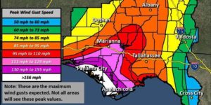
The impacts forecasted for our area remain relatively unchanged. Most of the county is at risk of seeing wind gusts up to 73mph but the extreme Northwest corner of the County is shaded as possibly seeing gusts up to 85 mph. This would be the Hahira area and points north and west of there. The forward motion of the storm has not really picked up as expected so the timing for Tropical Storm conditions has slowed and we are now looking at approximately 2PM as being the time we expect the beginning of Tropical Storm Force winds to first arrive in Lowndes County.
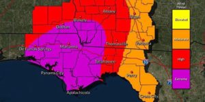
The tornado threat for Lowndes County is categorized as Elevated. Since our area is forecast to be in what is termed the “right front quadrant” of the storm, there is an increased risk of being impacted by tornadoes that may develop from the approaching severe weather. Tornados can form anywhere within a storm, but the northeast area tends to produce the most tornadic activity. Based on the current forecast, Lowndes County’s tornado threat increases significantly by tomorrow afternoon. Citizens are encouraged to remain aware of their surroundings during periods of severe weather. Know the difference between a watch and a warning. A watch indicates conditions are favorable, a warning means tornadic activity has been identified. In the event of a tornado warning, seek shelter away from windows and outside walls or doors.
The current forecast indicates Michael will bring 3-4 inches of rain to the area. Citizens should expect periods of heavy rainfall. While river flooding is not expected at this time, flash flooding from heavy rain during a short period of time is a legitimate concern. Citizens should avoid flooded roads, streets, and bridges. Significant infrastructure damage could exist under floodwaters. Crossing flooded areas could result in injury or loss of life. Do not put yourself or emergency responders in danger. Flash flood waters recede fairly quickly. A brief delay in travel could save a life.
SHELTERS-
Park Avenue United Methodist Church 100 E Park Ave, remains open for those without adequate shelter (homeless, mobile homes, substandard housing) and those who may have medically necessary electrical equipment. Citizens planning to seek shelter should do so now. Once severe weather begins to impact our area, citizens should shelter in place.
Projected wind speeds are not favorable for those staying in recreational vehicles. If you are in a motor home or recreational vehicle, please seek shelter in a more permanent shelter.
CURFEWS & EVACUATIONS
No curfews have been issued for Lowndes County, nor are there expected to be any. In addition, no evacuation orders have been issued at this time. Local law enforcement continues to encourage everyone to stay off roadways for the duration of the storm.
SCHOOLS-
All of the local public and private K-12 schools will be closed Wednesday and Thursday. An assessment will be made Thursday as to whether or not they will open on Friday. All of the local colleges (VSU, GMC, Wiregrass) are also closed Wednesday and Thursday.
PETS-
Please remember local ordinances require pets to be kept safe during periods of severe weather. In the event pets cannot be brought inside, pet owners are still responsible for providing a safe shelter.
GENERAL-
Lowndes County Emergency Management will continue to monitor conditions as Hurricane Michael develops. In the event severe weather results in downed trees and power lines, citizens should be prepared to sustain themselves for a three-day period. Supplies such as bottled water, non-perishable food items, prescription medications, flashlights, batteries, infant supplies, cleaning supplies, first aid items, etc., should be on hand. For preparedness checklists visit www.ready.ga.gov.
As with any response, communication remains key. Emergency Management Officials would like to remind citizens in Lowndes County that the Tallahassee Division of the National Weather service is the official government weather source for our area. In addition, citizens are encouraged to sign up for CodeRed, Lowndes County’s free emergency notification system, by visitingwww.lowndescounty.com, and clicking on the CodeRed icon. Emergency Management will use CodeRed for specific messaging and citizens may opt in to receive weather warnings directly from the National Weather Service. In the event other communication options fail, citizens are should have a working, NOAA weather radio. Citizens may also follow Lowndes County Emergency Management on Facebook by liking, EMA Lowndes.
CITY OF VALDOSTA
There will be no sanitation services on Wednesday, October 10. Wednesday and Thursday will be collected on Thursday, October 11. The City’s “See-Click-Fix” app can be used to report public property issues within the city limits.
Additional information will be released as it becomes available. Please let us know if you have any questions or need additional information.
UPDATE: Wednesday, 10/11 10:15 a.m.
There are no curfews in Lowndes County, nor is there expected to be. Further, no evacuation orders have been issued. Citizens should be prepared to shelter in place by 12:00 noon today. Please do not call 911 for weather information or response updates. Dial 911 only in the event of an emergency. Valdosta, A City Without Limits Lowndes County, GA #Michael #lowndesema
UPDATE: Wednesday, 10/10 7:20 a.m.
Emergency Management’s update this morning with the Tallahassee Division of NWS does not indicate a substantial change in the forecast for our area. Strong Tropical Storm force winds will impact our area later this morning. Citizens should be prepared for power outages. Tornadoes remain a concern. Please continue to monitor the Tallahassee Division of the NWS for watches and warnings. Citizens are encouraged to stay off roads for the duration of the storm. All downed power lines should be considered live until restored by professionals.
UPDATE: Wednesday, 10/10, 4:00 a.m.
Good morning, Hurricane Michael is now at a Category 4. Damaging winds will impact our area over the next 24-36 hours. Continue to prepare by securing outdoor items and providing a safe location for pets. Citizens should be prepared for power outages later today. More detailed information will be released after our morning brief with the NWS. Our thoughts and prayers remain with our Florida neighbors.
Update: Tuesday, 10/9 8:55pm
There will be an update in the morning after the NWS releases morning graphics. The Emergency Operations Center activates at 5:00 a.m., we look forward to hearing from you all tomorrow. Be prepared, stay safe.
Michael is now a dangerous Category 3 Major Hurricane.
· Forward motion is consistent at 12mph. It is expected to increase in forward speed but the lack of an increase to this point has resulted in a slight adjustment to anticipated timing of Tropical Storm Force Wind arrival. The timing has been adjusted by about 2 hours so the earliest reasonable time is still early morning on Wednesday but the most likely time when we will begin to see sustained winds in excess of 39 mph is midmorning on Wednesday.
· Rainfall is still projected at 3-4 inches but heavy rains can still produce momentary flash flooding.
· Park Avenue United Methodist Church is opening as a safe haven shelter for those seeking refuge from the high winds, such as the homeless, those in mobile homes, those with substandard housing that may not withstand the high winds and those who have a medical necessity for electricity due to medical equipment. They will open at 7PM tonight and remain open until Noon on Thursday. Additional shelters will be made available if Park Avenue nears capacity.
· The EOC will open for full activation at 5AM tomorrow morning.
· All local schools, local government offices, Public Health offices and Health Department will be closed Wednesday and Thursday.
Update: Tuesday, 10/9 5pm
A Tropical Storm Warning remains in effect for Lowndes County. According to the latest information shared by the National Weather Service, confidence remains high that there will be significant impacts across the area. Rainfall estimates remain low at 2-3 inches. Tornado activity remains a concern beginning Wednesday morning & continuing through Thursday. The current forecast indicates severe weather may not impact our area until between 8:00-10:00 a.m. Wednesday. Please be prepared to adjust travel and schedules as needed.
UPDATE: Tuesday, 10/9, 1:43 p.m.
The Lowndes County Emergency Operations Center will be fully activated at 5 a.m. Wednesday morning. It will be staffed until the storm has moved out of the area and emergency response levels return to normal. This could mean a 36-48 hour activation. City and County utilities, public works and all public safety agencies have increased manning and will be addressing storm related matters for the duration. In addition, Chairman Slaughter and Mayor Gayle have declared a local State of Emergency to enact the Lowndes County Emergency Operations Plan and to “Prohibit Overcharging for Goods, Materials, Services and Housing during a State of Emergency.
Current planning considerations for Hurricane Michael include the following:
WEATHER–
Hurricane Michael has continued to strengthen and is currently a Category 2 Storm packing sustained winds of 100mph. It is expected to reach Category 3 strength before making landfall around 1PM tomorrow near Panama City, FL. Even though landfall won’t occur until tomorrow afternoon the impacts will be felt far in advance of landfall. We are expecting Tropical Storm Force winds (39mph or greater) by 8AM tomorrow. These winds will gradually increase up to 60+ mph with Hurricane Force gusts (greater than 74 mph) certainly possible. Confidence is high that there will be significant impacts across the area. Lowndes County remains in a Tropical Storm warning. Strong winds are expected to lead to downed trees resulting in widespread, prolonged power outages.
The earliest reasonable time of arrival is 2:00 a.m. Wednesday, with the most likely time of arrival 8:00 a.m. Wednesday. The main threat for tornadoes remains Wednesday morning and continues through Thursday.
The tornado threat for Lowndes County is categorized as Elevated. Since our area is forecast to be in what is termed the “right front quadrant” of the storm, there is an increased risk of being impacted by tornadoes that may develop from the approaching severe weather. Tornadoes can form anywhere within a storm, but the northeast area tends to produce the most tornadic activity. Based on the current forecast, Lowndes County’s tornado threat increases significantly by tomorrow afternoon. Citizens are encouraged to remain aware of their surroundings during periods of severe weather. Know the difference between a watch and a warning. A watch indicates conditions are favorable, a warning means tornadic activity has been identified. In the event of a tornado warning, seek shelter away from windows and outside walls or doors.
The current forecast indicates Michael will bring 3-4 inches of rain to the area. Citizens should expect periods of heavy rainfall. While river flooding is not expected at this time, flash flooding from heavy rain during a short period of time is a legitimate concern. Citizens should avoid flooded roads, streets, and bridges. Significant infrastructure damage could exist under floodwaters. Crossing flooded areas could result in injury or loss of life. Do not put yourself or emergency responders in danger. Flash flood waters recede fairly quickly. A brief delay in travel could save a life.
SHELTERS-
Park Avenue United Methodist Church 100 E Park Ave, will be opening as a shelter for those without adequate shelter (homeless, mobile homes, substandard housing) and those who may have medically necessary electrical equipment. They will open beginning at 7PM tonight and remain open until 12:00 noon, on Thursday.
Projected wind speeds are not favorable for those staying in recreational vehicles. If you are in a motor home or recreational vehicle, please seek shelter in a more permanent shelter.
SCHOOLS-
All of the local public and private K-12 schools will be closed Wednesday and Thursday. An assessment will be made Thursday as to whether or not they will open on Friday. All of the local colleges (VSU, GMC, Wiregrass) are also closed Wednesday and Thursday.
PETS-
Please remember local ordinances require pets to be kept safe during periods of severe weather. In the event pets cannot be brought inside, pet owners are still responsible for providing a safe shelter.
GENERAL-
Lowndes County Emergency Management will continue to monitor conditions as Hurricane Michael develops. In the event severe weather results in downed trees and power lines, citizens should be prepared to sustain themselves for a three-day period. Supplies such as bottled water, non-perishable food items, prescription medications, flashlights, batteries, infant supplies, cleaning supplies, first aid items, etc., should be on hand. For preparedness checklists visit www.ready.ga.gov.
As with any response, communication remains key. Emergency Management Officials would like to remind citizens in Lowndes County that the Tallahassee Division of the National Weather service is the official government weather source for our area. In addition, citizens are encouraged to sign up for CodeRed, Lowndes County’s free emergency notification system, by visiting www.lowndescounty.com, and clicking on the CodeRed icon. Emergency Management will use CodeRed for specific messaging and citizens may opt in to receive weather warnings directly from the National Weather Service. In the event other communication options fail, citizens are should have a working, NOAA weather radio. Citizens may also follow Lowndes County Emergency Management on Facebook by liking, EMA Lowndes.
CITY OF VALDOSTA
There will be no sanitation services on Wednesday, October 10. Wednesday and Thursday will be collected on Thursday, October 11. The City’s “See-Click-Fix” app can be used to report public property issues within the city limits.
Additional information will be released as it becomes available. Please let us know if you have any questions or need additional information.
UPDATE: Tuesday, October 9, 2018, 9:26 a.m.
UPDATE: Tuesday, October 9, 2018 noon
“Based on the latest forecast for Hurricane Michael and acting on a recommendation from Georgia Emergency Management and Homeland Security Agency (GEMA/HS) officials, Gov. Nathan Deal today issued an emergency declaration for 92 Georgia counties. The emergency declaration is effective for seven days and makes all state resources available to local governments and entities within the impacted area of the hurricane.” -From the Office of Governor Deal
UPDATE: Tuesday, 9:14 a.m.
CITY, COUNTY OFFICIALS CONTINUE TO MONITOR HURRICANE MICHAEL
LOWNDES – According to the latest forecast, Lowndes County has an 80 percent chance of experiencing Tropical Storm Force winds (39-74 mph) and a 30 percent chance of experiencing Hurricane Force winds of 75 mph or greater. This being the case, citizens should take advantage of the time between now and when winds arrive to secure outdoor furniture, toys, trampolines, etc.
The main area of uncertainty with the current forecast is timing. The forward motion of the storm has fluctuated and it is uncertain how the forward movement will be affected once the storm reaches the warm waters of the Gulf of Mexico. Currently, the earliest reasonable time of arrival of Tropical Storm Force winds is late Tuesday night or early Wednesday morning. Based on the current forecast, the most likely time Lowndes County could feel the impact of Tropical Storm force winds is Wednesday mid-morning. Regardless, citizens should prepare now to ensure readiness in the event the storm arrives earlier than expected.
The tornado threat for Lowndes County is categorized as Elevated. Since our area is forecast to be in what is termed the “right front quadrant” of the storm, there is an increased risk of being impacted by tornadoes that may develop from the approaching severe weather. Tornadoes can form anywhere within a storm, but the northeast area tends to produce the most tornadic activity. Based on the current forecast, Lowndes County’s tornado threat increases significantly by tomorrow afternoon. Citizens are encouraged to remain aware of their surroundings during periods of severe weather. Know the difference between a watch and a warning. A watch indicates conditions are favorable, a warning means tornadic activity has been identified. In the event of a tornado warning, seek shelter away from windows and outside walls or doors.
The current forecast indicates Michael will bring 4-5 inches of rain to the area. Citizens should expect periods of heavy rainfall. While river flooding is not expected at this time, flash flooding from heavy rain during a short period of time is a legitimate concern. Citizens should avoid flooded roads, streets, and bridges. Significant infrastructure damage could exist under floodwaters. Crossing flooded areas could result in injury or loss of life. Do not put yourself or emergency responders in danger. Flash flood waters recede fairly quickly. A brief delay in travel could save a life.
Lowndes County Emergency Management will continue to monitor conditions as Tropical Storm Michael develops. In the event severe weather results in downed trees and power lines, citizens should be prepared to sustain themselves for a three-day period. Supplies such as bottled water, non-perishable food items, prescription medications, flashlights, batteries, infant supplies, cleaning supplies, first aid items, etc., should be on hand. For preparedness checklists visit www.ready.ga.gov.
Please remember local ordinances require pets to be kept safe during periods of severe weather. In the event pets cannot be brought inside, pet owners are still responsible for providing a safe shelter.
As with any response, communication remains key. Emergency Management Officials would like to remind citizens in Lowndes County that the Tallahassee Division of the National Weather service is the official government weather source for our area. In addition, citizens are encouraged to sign up for CodeRed, Lowndes County’s free emergency notification system, by visiting www.lowndescounty.com, and clicking on the CodeRed icon. Emergency Management will use CodeRed for specific messaging and citizens may opt in to receive weather warnings directly from the National Weather Service. In the event other communication options fail, citizens are should have a working, NOAA weather radio. Citizens may also follow Lowndes County Emergency Management on Facebook by liking, EMA Lowndes.”
Here are the latest updates and cautions from the Lowndes Emergency Management Agency:
10/8/18 4:55 pm
No significant changes to report other than wind speed probabilities have increassed by 10% for both tropical storm force and hurricane force winds. Lowndes County remains under a Tropical Storm Watch. Look for further updates in the morning.
10/8/18 12:00 pm
At 9:30 a.m. this morning, Lowndes County Emergency Management Director, Ashley Tye, participated in a conference call with the Tallahassee Division of the National Weather Service. According to the latest forecast, Lowndes County has a 70% chance of experiencing Tropical Storm Force winds (39-74 mph) and a 20% chance of experiencing Hurricane Force winds of 75 mph or greater. This being the case, citizens should take advantage of the time between now and when winds arrive to secure outdoor furniture, toys, trampolines, etc.
The main area of uncertainty with the current forecast is timing. The forward motion of the storm has fluctuated and it is uncertain how the forward movement will be affected once the storm reaches the warm waters of the Gulf of Mexico. Currently, the earliest reasonable time of arrival of Tropical Storm Force winds is late Tuesday night or early Wednesday morning. Based on the current forecast, the most likely time Lowndes County could feel the impact of Tropical Storm force winds is Wednesday mid-morning. Regardless, citizens should prepare now to ensure readiness in the event the storm arrives earlier than expected.
The tornado threat for Lowndes County is categorized as Elevated. Since our area is forecast to be in what is termed the “right front quadrant” of the storm, there is an increased risk of being impacted by tornadoes that may develop from the approaching severe weather. Tornados can form anywhere within a storm, but the northeast area tends to produce the most tornadic activity. Based on the current forecast, Lowndes County’s tornado threat increases significantly by tomorrow afternoon. Citizens are encouraged to remain aware of their surroundings during periods of severe weather. Know the difference between a watch and a warning. A watch indicates conditions are favorable, a warning means tornadic activity has been identified. In the event of a tornado warning, seek shelter away from windows and outside walls or doors.
The current forecast indicates Michael will bring 4-5 inches of rain to the area. Citizens should expect periods of heavy rainfall. While river flooding is not expected at this time, flash flooding from heavy rain during a short period of time is a legitimate concern. Citizens should avoid flooded roads, streets, and bridges. Significant infrastructure damage could exist under floodwaters. Crossing flooded areas could result in injury or loss of life. Do not put yourself or emergency responders in danger. Flash flood waters recede fairly quickly. A brief delay in travel could save a life.
Lowndes County Emergency Management will continue to monitor conditions as Tropical Storm Michael develops. In the event severe weather results in downed trees and power lines, citizens should be prepared to sustain themselves for a three-day period. Supplies such as bottled water, non-perishable food items, prescription medications, flashlights, batteries, infant supplies, cleaning supplies, first aid items, etc., should be on hand. For preparedness checklists visit www.ready.ga.gov.
Please remember local ordinances require pets to be kept safe during periods of severe weather. In the event pets cannot be brought inside, pet owners are still responsible for providing a safe shelter.
As with any response, communication remains key. Emergency Management Officials would like to remind citizens in Lowndes County that the Tallahassee Division of the National Weather service is the official government weather source for our area. In addition, citizens are encouraged to sign up for CodeRed, Lowndes County’s free emergency notification system, by visiting www.lowndescounty.com, and clicking on the CodeRed icon. Emergency Management will use CodeRed for specific messaging and citizens may opt in to receive weather warnings directly from the National Weather Service. In the event other communication options fail, citizens are should have a working, NOAA weather radio. Citizens may also follow Lowndes County Emergency Management on Facebook by liking, EMA Lowndes